
EDAI

Earth Design Analysis & Innovation
Watershed | Geologic Hazards | Landscape

Are tourists at risk in this canyon?

Assessing landslide hazards in Baawerta, Lebanon

Assess your building site to be informed of the probability that this may occur.
Are tourists at risk in this canyon?
Geologic Hazard Assessment
- Development Suitability
- Risk Assessment
- Risk Management

hydro-mulch as a slope stability treatment after fire


hydro-mulch as a slope stability treatment after fire
Emergency & Disaster Response for Watershed and Infrastructure Concerns
-
Burned Area Emergency Response (BAER): Hydrologic and Geologic Assessment and Treatment Implementation
-
Flood Mitigation & Repair
-
Quantifying expected runoff before and after landscape changes such as wildland fire.
-
Designing protection of threatened infrastructure
-
Slope stability solutions
-
Cost estimating

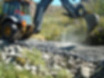
Stream crossing removal


Fully recontoured road shortly after equipment work has been completed. Photo shows two ephemeral stream crossings restored.
Stream crossing removal
Road Decommissioning
When a greater degree of landscape restoration is desired, complete decommissioning of roads may be the best option.
- Design
- Cost estimating
- Inspection


Constructing a forest road wetland crossing

Improving drainage and protecting a wilderness trail from expected increased runoff as the forest recovers from fire
Constructing a forest road wetland crossing
Watershed Assessment
&
Water Quality Assessment
-
Watershed Management Plans
-
Broad- or small-scale analysis of impacts and possible mitigations of impacts in a watershed
-
Water quality testing
Road & Trail Design
-
Water-way and wetland protection
-
Improvements to reduce maintenance and costs
-
Alignment planning
-
Stream crossing design

GIS Analysis
Geographic Information System - utilizing digital spatial data to calculate results and create mapping products.
GIS is an essential tool employed at EDAI, ltd. in most landscape and watershed projects.

Post-wildfire debris flow prediction offered by EDAI, ltd. is informed by in-depth utilization of mathematical, geospatial modeling calculation methods, combined with 28 years of experience observing and analyzing debris flows on site throughout the western United States, and in great varieties of environments, topography, precipitation regimes, climates, vegetation types, soils and lithologies.